
CLINTON
CLINTON PROJECT
Cu, Zn, Ag
OVERVIEW
POSITIONED IN A HIGHLY PROSPECTIVE VMS BELT - HIGH-GRADE INTERSECTIONS
-
The 100%-owned Clinton Project is situated ~20 km SouthWest of the town of Megantic, north of the Maine border.
-
The Clinton Project encompasses ~20km of favourable stratigraphy within the Clinton River volcano-sedimentary belt. It hosts a series of Cu–Zn rich volcanogenic massive sulphide (VMS) mineralization lenses extending over a 5-kilometre NorthEast horizon.
-
Previous work highlighted potential to expand known mineralization and to discover new copper-rich massive sulphides lenses:
-
The 2022 program intersected 3.15 metres at 3.30% Cu and 12.64 g/t Ag, extending the known Clinton A massive sulphide lens by more than 100 metres along strike (FNC press release dated 14/06/2022;).
-
Q12023 Induced polarization (IP) survey delineated high priority anomalies along targeted favourable geological horizon on an overlooked part of the property.
-
Most mineralized lenses at Clinton are open at depth and some lenses (such as A and E) remain open along strike.
-
Modern exploration techniques, such as the IP survey deployed in Q12023 have the potential to detect new mineralized lenses missed by previous operators.
-
-
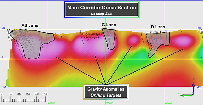
Recent work reported positive results from a Gravity Survey conducted in December 2024 at the Clinton volcanogenic massive sulfide project, situated in the past-producing area of the Appalachian region of Southern Québec, one of the top jurisdictions globally in terms of attractiveness for exploration investments (Annual Survey of Mining Companies 2023, Fraser Institute). The recent work conducted at Clinton was successful at identifying multiple, new, high-density targets at depth and delineated the potential VMS deposit root system, fundamental elements to allow for the extension of current mineralization, to demonstrate a significant VMS deposit at Clinton and provide for new copper discovery. The results of the work conducted at Clinton are highly encouraging, proving out that new targets exist at depth, conceivably larger than on surface, with the potential to extend the already defined mineralized lenses and uncover new meaningful copper-zinc bearing massive sulphides lenses. The Gravity Survey consisted of the acquisition of 2,000 gravity stations, on line spaced every 100 meters with reading stations every 25 meters, in the northern sector of the Clinton property. The survey investigated the potential of identifying deep seated VMS lenses under the known mineralized occurrences of the Clinton Project, which hosts historic production that occurred during the 1970’s and multiple copper-bearing mineralized lenses. Particular attention was provided to the favorable horizon capping the “AB”, “C”, “D”, “E” and “O” lenses.
-
Highlights
-
Twenty-three (23) anomalies indicative of sources in positive density contrast with the host rocks have been identified. These gravity sources are essentially regrouped within the confines of three (3) NNE/SSW oriented, slightly broader, anomalous corridors that seem to feature prospective bands of rocks within, or in the vicinity of which are observed, known mineral lenses.
-
The Gravity Survey effectively delineated the geologically favorable horizon hosting the known "AB," "C," "D," and "E" lenses. The known lenses, which exhibit a significant density contrast with the surrounding host rocks, correspond to distinct gravity anomalies, confirming the survey's effectiveness. Critically, the survey also identified new, high-density targets at depth, both below and between the known lenses, which represent compelling drill targets for Cu-Zn massive sulfide mineralization.
-
A second, stratigraphically lower corridor, which correlates with the known "V Zone," may represent the root system of a volcanogenic massive sulfide (VMS) deposit. The property's highest-grade intersection to date, 2.78% Cu, 16.9 g/t Ag over 24.7 meters (refer to press release dated October 14, 2014) was drilled along this corridor. The Gravity Survey identified a new, high-density target along this trend, located below the known "C" lens. This target constitutes another high-priority drill target on the Clinton Project.
-

GEOLOGY
The Clinton property, located in the Northern Appalachian, in the Eastern Townships of Québec, some 20 kilometres southwest of the town of Mégantic, may represent a structural window within the Clinton River Anticlinorium of Ordovician Age. This window is situated between two major structures of the Northern Appalachian; the Gaspé-Connecticut Valley Synclinorium to the NorthWest and the Boundary Mountains Anticlinorium to the SouthEast. The project is underlain by volcanic rocks of the Chesham Melange, and sedimentary rocks of the Clinton Formation, and host numerous precious metal bearing VMS occurrences and small past producers, along a NE trend across the property.
The Clinton mine produced between 1973-75, and reportedly mined an average grade of 2.65% Cu, 2.43% Zn, 30.03 gpt Ag, and 0.45 gpt Au [Groupe Minier Sullivan, 1973 Annual report] and is characterized by five small sulphide lenses. Fancamp has held the Clinton Project since 2010, and has conducted multiple drill programs and tested various targets. Some 62,354 metres of drilling across 297 holes was performed since 1953 (Link), since 2010, Fancamp drilled a total of 11,000 metres extending multiple lenses.
The best intercepts returned from Fancamp work was 1.79% Cu over 6.19 metres within a 14.58 metres wide zone of 1.09% Cu (FNC press release dated 16/07/2012), and 1.27% Cu, 1.14% Zn, and 11 gpt Ag over 11 metres (V3 zone, FNC press release dated 14/10/2014), and 2.78% Cu and 16.9 gpt Ag over 24.7 metres (V1 zone, FNC press release dated 14/10/2014).
EXPLORATION
Fancamp’s 2022-2023 drill campaigns resulted in lenses A and B being considered as a contiguous mineralized zone, delineating the expansion potential of VMS lenses.
Total of 1,294 metres in 6 holes drilled in 2022 in the northern part of the property; exhibiting success with Clinton historical lens “A” being extended to a minimum of 100 metres along strike, at shallow depth (FNC press release June 14, 2022). Potential of along strike continuity of both the A and E Lenses, and IP anomalies along a favourable geological horizon. A total of 2,678 metres in 11 holes were drilled in 2023.
Drill Program Highlights:
-
Hole CLDD-22-02: 3.15 metres @ 3.30% Cu and 12.64 g/t Ag, extending historical lens “A” mineralization 100 metres along strike, at 50 metres below surface (FNC press release June 14, 2022).
-
Hole CLDD-22-03: 2.00 metres @ 0.54% Cu, down-dip extension from intersection in hole CLDD-22-02 (FNC press release June 14, 2022).
-
Hole CLDD-22-01: 3.00 metres @ 0.72% Cu, 2.87 g/t Ag and 0.02 g/t Au (FNC press release Aug 17, 2022).
-
Overall best intersection at “V” Zone: 24.7 metres @ 2.78% Cu and 16.9 g/t Ag (FNC press release Oct. 14, 2014).


